HPC User Report from P. Friedl (Department of Geography)
Interactive data portal for global glacier variables derived from satellite remote sensing
Intensity offset tracking and interferometry are applied to continuous streams and archived imagery, acquired by ESA’s (European Space Agency) Sentinel-1 radar satellites, in order to produce global maps of glacier velocities and glacier outlines. The derived products, together with other glacier products generated in the department of Geography (e.g. glacier elevation change maps), will be made accessible and explorable via an interactive online data portal.
Motivation and problem definition
The ice masses of the world’s glaciers and ice caps glaciers are important storages of freshwater that are highly affected by climate change. Continuous monitoring of glaciological variables such as ice velocity, ice extent and ice elevation provides key information on glacier evolution, which is essential for e.g. assessing global sea level rise, as well as for regional water resource and natural hazard management. Although field measurements are still important data sources in glaciology, they are not feasible over large and inaccessible regions. In contrast, modern radar satellite systems like ESA’s Sentinel-1 allow to automatically derive continuous time series of glaciological parameters on global scales, independent of weather conditions or daylight. However, this requires a deep knowledge in radar remote sensing, suitable processing algorithms and a powerful hardware environment, which is not feasible for every potential interest group of such data. Hence, the aim is to routinely generate continuously updated global glaciological products from radar remote sensing for glaciers and ice caps in ten regions outside of the polar ice sheets (e.g. High-mountain Asia, Patagonia, Alaska, Svalbard, Novaya Zemlya, etc.) and to distribute them via an interactive open access online portal as a free service for the scientific community, educators, political decision makers and interested citizens.
Methods and codes

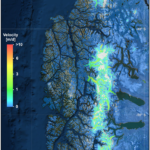
Glacier velocities are fully automatically processed by applying a well-established intensity offset tracking method to archived (~ 25.000 scenes) and new available Sentinel-1 acquisitions immediately after becoming available (~ 10.000 scenes per year). The method is based on tracking the motion of prominent surface features (e.g. crevasses) or small-scale intensity patterns in two consecutive radar images by using a moving window approach. Glacier outlines are automatically delineated based on interferometric coherence, which is a measure of the similarity of the phase information in two consecutive radar images. As coherence is high over stable ground outside of a glacier, but low even on very slow-moving glacier termini, the glacier outline can be precisely delineated. In contrast to widely used methods based on optical imagery, this method also works in areas where glaciers are covered by debris and therefore hard to discriminate from its (rocky) surrounding.
Results
The generated glaciological products are suitable for several applications. Dense series of large-scale velocity measurements allow to assess changes in seasonal glacier speed and long-term velocity trends due to climatic forcing on regional and continental/global scales. Yearly stacks of surface velocity can be used as inputs to models that derive continental-wide ice thickness estimates where no in-situ measurements exist. Furthermore, large-scale measurements of ice elevation together with time series of glacier outlines enable to assess the impact of climate change on global glacier extend, ice elevation, glacier mass-balance and sea level rise.
Outreach
The project was presented at the Nationales Forum für Fernerkundung und Copernicus 2018 and the European Geosciences Union (EGU) General Assembly in 2019. The research is supported by the DLR/BMWi project 1029 50EE1716. All generated products will be publicly made available via an interactive web portal.
Researcher’s Bio and Affiliation
After completing the state examination (high-school teaching degree) in Geography and Economics at the University of Bayreuth, Peter Friedl completed the MSc in Physical Geography at FAU. Peter Friedl has recently submitted his PhD thesis. During his PhD at the German Aerospace Center (DLR) and at FAU he focused on the derivation of glaciological parameters from time series of multi-mission remote sensing data and applications to glaciers in Antarctica and the Karakoram.
